|
Home
Summary
Calendar
Auto/Aviation/Trains
Aviation
Space
Automobiles
Ships & Naval
Trains
Boating
Canoeing
Kayaking
Rafting
Sailing
Windsurfing
Camping
Group
State
National
County
Regional
Private
Caving
Climbing
Indoor
Rock
Cycling
Fish/Wildlife & Nature
Fishing
High Ventures
Hiking
Historic
Local
Rim of the Bay
Skyline
Bay Area Ridge
Tahoe Rim
Pacific Crest
Maps
Other Outings
Outing Reports
Planning
Reservations
Service Outings
Water Sports
Scuba
Stand Up Paddling
Surfing
Swimming
Winter Sports
Skiing/Boarding
Snow Camping
|
Cycling Henry Coe State Park
In general, Henry Coe State Park is a very challenging area for mountain
biking because it is so hilly. However, this five-mile out-and-back ride
is an easy one, suitable for the intermediate mountain biker. There's a
short, moderate incline at the beginning of the ride, but the rest is
downhill through rolling terrain into Manzanita Point Group Camp. The
trail is well signed and follows a wide fire road of gravel and dirt.
Henry Coe is California's second-largest state park at 67,000 acres.
Elevations range from 800' to 3,500', resulting in diverse scenery that
includes grassland, oak and ponderosa pine forests, and deep canyons.
There is a great website that has pictures and lists of birds and
wildflowers at the park.
http://www.coepark.org/
For most riders, this brief out-and-back will be a nice afternoon ride,
and a good introduction to the variety of mountain biking in this area.
In certain parts of the park, additional trails are open to mountain
bikers. These trails are farther away from park headquarters and are
suitable for the intermediate to advanced rider. Give yourself the
better part of a whole day to explore these longer trails, which take
longer to ride than you might think in this hilly country.
Finding the trail: From US 101, take the East Dunne Avenue exit
and bear east at Morgan Hill. Follow the signs up a narrow, winding road
for 13 miles past Anderson Reservoir until you reach the dead end at
park headquarters. There's a $3 day-use parking fee for the small lot in
which you'll park your car.

|

|
|

|
|
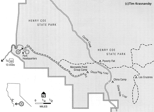
Henry Coe State
Park
Trail Map |
|

|
Length/configuration: 5-mile out-and-back. |
|

|
Aerobic
difficulty: Short moderate incline at the beginning
followed by rolling terrain. |
|

|
Technical
difficulty: Easy. |
|

|
General
Location: South of San Jose and 13 miles east of US 101 in
Morgan Hill. |
|

|
Elevation
Change: Your starting point in the parking area is at
2,600'. The trail climbs 800' before dropping down to 2,150'.
There's a short climb of 50' up to Manzanita Point, the outer
end of this out-and-back. |
|

|
Season:
The best riding is in the spring, when the hills still are
green but the trails are not too wet, and in the fall, when
the oak leaves turn colors and the temperatures reach the
comfortable 60s and 70s. Summer can be scorchingly hot (carry
extra water), and winter rains sometimes close the trails
altogether. |
|

|
Services:
Rest rooms, water, a pay phone, and camping facilities are
available at the parking area next to park headquarters. There
are also several wilderness campsites available to bikers;
call park headquarters for more information: (408) 779-2728.
For all other services, go to Morgan Hill. |
|

|
Hazards:
Watch out for other trail users and always yield to horses and
hikers. Rattlesnakes are found in the park. They are not
aggressive but will defend themselves if harassed. If you see
one, leave it alone! Ticks are also found in this area, so
check your skin and clothing carefully at the end of the ride
and get rid of these pests before they dig in. |
|

|
Rescue
Index: In any emergency, return to park headquarters for
assistance. There is a pay phone located there. |
|

|
Land
Status: California state park. |
|

|
Maps:
Park headquarters supplies a small, free map that shows what
areas are open to mountain bikes and also indicates mileages
to many points in the park. The museum shop has larger, more
comprehensive maps for sale. |
|
|
