Cycling
Nisene Marks State Park
SCOUT OUTINGS
Aviation
Space
Automobiles
Ships & Naval
Trains
Canoeing
Kayaking
Rafting
Sailing
Windsurfing
State
National
County
Regional
Indoor
Rock
Historic
Local
Rim of the Bay
Skyline
Bay Area Ridge
Tahoe Rim
Pacific Crest
Scuba
Stand Up Paddling
Surfing
Swimming
|
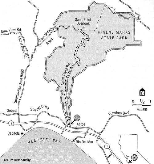
Aptos Creek Fire Road |
|
|
|
Length/configuration: 18-mile out-and-back. |
|
|
Aerobic difficulty: Easy, gentle riding. |
|
|
Technical difficulty: Pothole-riddled gravel road with cars for the first 2.2 miles. |
|
|
General Location: About 4 miles south of Santa Cruz. |
|
|
Elevation Change: Aptos Creek Road leaves Soquel Drive at an elevation of about 200'. In 9 miles it climbs to 1,600' at Sand Point Overlook for a total elevation gain of approximately 1,400'. |
|
|
Season: The road is open to riding year-round and is ideal from spring through late fall. Spring brings a multitude of wildflowers to the forest, including huckleberry, Western coltsfoot, fat Solomon's seal, gooseberry, thimbleberry, blackberry, and miner's lettuce. During the summer, this trail remains cool in the shade of overhanging trees. The weather often remains dry well into November, but winter rains can make this trail rather muddy. It's best to avoid wet winter rides because of trail erosion. |
|
|
Services: No facilities are available at the park; all services are found in the town of Aptos or in Santa Cruz, 4 miles north of Aptos on CA 1. For camping, New Brighton State Beach is just one exit north on CA 1. There's also camping in the park at Westridge Trail Camp, but you must have advance reservations; call (408) 335-4598. |
|
|
Hazards: Be sure to ride single file on the first section of this ride. The road is narrow and has two-way car traffic. Once on the trail, remember to watch for hikers and be sure they know you are behind them before passing. Also, watch for oncoming bike traffic. |
|
|
Rescue Index: Nisene Marks is well used by runners, walkers, and mountain bikers year-round. You'll often see at least 10 people on this ride, even in the middle of January, so make your way back towards the trailhead for assistance. The nearest phone is at the steel bridge over Aptos Creek. |
|
|
Land Status: California state park. |
|
|
Maps: The park puts out a great map with lots of information for $0.50. The park rangers sell it but are not always around. The best way to get this map is to send $0.50 to park headquarters with your request: The Forest of Nisene Marks State Park, 101 North Big Trees Park Road, Felton, CA 95018. |